Glacier National Park

June 23, 2018
We visited early in the summer and we fortunate that the Going-to-the-Sun Road opened that day we visited.
West Entrance
If you are coming from Kalispell, Whitefish or Columbia Falls (like we did), Montana, you’ll enter Glacier through the West Entrance Station. This popular portal receives heavy use during the summer, so don’t be surprised if traffic is backed up and there is a wait.
We were lucky and only waited about 5 minutes got get through. The far right lane is for receipts and passes and is a much longer line but it actually moves quicker than the others. The West Entrance provides easy access to the Lake McDonald area, the Apgar Visitor Center, and Going-to-the-Sun Road.
Sacred Dancing Cascades


A few miles northeast of Lake McDonald Lodge is a pullout where you see a series of waterfalls along McDonald Creek called the Sacred Dancing Cascades. From your vehicle, it’s only a couple of minutes’ walk to a viewing deck, which offers prime viewing of turquoise water frothing to white as it cascades over rocks in the riverbed.


Red Rock Point


Deep burnt-red rocks contrast against icy glacial turquoise waters at Red Rock Point. A short walk from Going-to-the-Sun Road takes you to where McDonald Creek makes its way through red mudstone. The bright red and coral colors against the clear vibrant water makes for an pictureous scene.
Avalanche Exhibit


Avalanches rip down the mountainsides once Going-to-the-Sun Road is closed for winter. As you travel through the steep, mountainous terrain of Glacier National Park, you might see avalanche chutes, marked by flattened forests and brush and berry bushes that fill in areas where trees once stood. These chutes are prime places to see wildlife, including grizzlies which forage for the remains of animals snow slides might have caught and killed.
The Avalanche Exhibit along Going-to-the-Sun Road provides views of several avalanche chutes on Mt. Cannon.
The Loop


This parking area offers views of Heaven’s Peak, but not on this day as we has low cloud cover, as well as forest regrowth in an area ravaged by fire in 2003.
Weeping Wall


Drive through a waterfall as you descend Going-to-the-Sun Road, about three miles west of Logan Pass. You pass not just by, but through, the water of the famous Weeping Wall. In early season this beautiful rock face along the Garden Wall gushes water from spring snowmelt above, drenching the road and even people inside open-windowed vehicles. If you don’t want to get wet, make sure you roll up!

Logans Pass Visitor Center

Situated at the top of Going-to-the-Sun Road, the Logan Pass Visitor Center is open mid-June to mid-September. Inside, you’ll find exhibits on the alpine zone plants and animals that live at 6,700-feet, where the visitor center is located. You can buy souvenirs in the gift shop, and there are also bathrooms and drinking water available.
A boardwalk behind the center protects the tundra from human footsteps. There can be snow in this area even in the summer, so bring a jacket in case it’s cold and windy. Keep your eyes open for wildlife. You might see mountain goats, big horn sheep, or even a grizzly bear.
Lunch Creek

Lunch Creek is as charming as its name sounds. Located one mile east of Logan Pass on Going-to-the-Sun Road, it’s the first creek the road crosses when heading east from the pass. You can walk from the pass, or drive to the ample parking lot.

The creek flows down a natural rock staircase in front of Pollock Mountain and is often surrounded by wildflowers in the summer.
Jackson Glacier Overlook


Don’t go to Glacier National Park and miss seeing one of the park’s namesake features – while you still can. Jackson Glacier Overlook, located east of Logan Pass, offers you the best chance to see a glacier from the road. A sign will tell you more about this and the park’s other glaciers, while also directing you where to look on Mount Jackson to see the large body of white that is one of the park’s 25 remaining glaciers.
On the way back to the truck we cam across this guy eating.


In 1850, there were an estimated 150 glaciers in the park. Research shows all the glaciers could be gone by 2030 if melt rates continue at the present speed.
Sunrift George
Formed when a small stream cut through a natural break in the rock, Sunrift Gorge is a straight, steep canyon cut through the bedrock just 200 hundred feet off the main road. Also at this location is one of the most beautiful bridges along the entire Going-to-the-Sun Road. Baring Creek Bridge is an excellent example of how native stone materials were used to blend the road into the landscape.

Baring Creek, a small stream, created the gorge by cutting through a natural break in the rock. Turquoise water now runs through the deep gorge.
Baring Creek Trail

A short hike under the bridge leads to Baring Falls along the Baring Creek Trail. About a quarter-of-a-mile away you can see Baring Falls. This waterfall drops about 25 feet over a rock ledge feeding into Baring Creek.

Wild Goose Island Overlook

You’ll likely recognize the scene at Wild Goose Island Viewpoint. The images of St. Mary Lake that appear on magazine covers and in brochures and calendars are most often taken here — it is one of the most photographed places in the world.

This iconic viewpoint showcases the best of Glacier: towering mountains rising 4,000 feet, and pristine lakes. You’ll see peaks like Red Eagle Mountain, Dusty Star Mountain, and Citadel Mountain that reach more than 8,000-feet high at their summits. Others, like Gunsight Mountain and Going-to-the-Sun Mountain, reach higher than 9,000 feet.
Leaving Wild Goose Island Overlook we came across tow black bears in the field along the road.


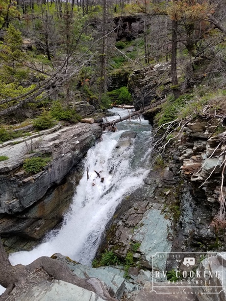
Avalanche Creek

Avalanche Creek, with its glacier-fed turquoise water and the bright-colored moss and lush foliage on its banks, has an ethereal quality. The most popular way to see the creek is by hiking the Trail of the Cedars, that takes you through an ancient cedar forest to a footbridge that crosses Avalanche Creek, and provides the best view of the stunning Avalanche Gorge, where the icy glacial rapids rush through a stone canyon.

It’s about a one-mile round-trip to the bridge. This area is one of the park’s most popular stops, so parking can be an issue. We couldn’t find parking in the morning and stopped on our way back in the afternoon.
***********************************************************************************************************
This post contains affiliate links, so I make a small commission if you purchase through my links – that support helps to keep this blog running.
Copyright Foodie Made Simple, LLC. All text, recipes and photographs are copyrighted and may not be published elsewhere without express permission. Pinterest, Twitter, Instagram, Tumbler, Google+ and Facebook users, you are welcome to “pin” photos! re-tweet and “share” links all you like, just don’t copy the recipes themselves. Fellow bloggers are welcome to repost my recipes, just write the recipe in your own words, use your own photograph, then link back to the original recipe on rvcookingmadesimple.com


Comments are closed.