Northern Arizona
July 11, 2018
Vermilion Cliffs National Monument

The 3,000-foot escarpment of the Vermilion Cliffs reveals seven major geologic formations in layer-cake fashion. This remote and unspoiled, 294,000-acre monument is a geologic treasure, containing Paria Plateau, Vermilion Cliffs, Coyote Buttes and Paria Canyon.


Vermilion Cliffs National Monument spans from the western rim of Marble Canyon to the boundary of Grand Staircase Escalante National Monument in Southern Utah. Visitors traveling to the North or South Rim of the Grand Canyon will traverse the southern boundary of the monument when they drive along highway 89A, which actually borders the Paria Canyon Vermilion Cliffs Wilderness section of the Monument.

Marble Canyon

Marble Canyon is the section of the Colorado River canyon in northern Arizona from Lee’s Ferry to the confluence with the Little Colorado River, which marks the beginning of the Grand Canyon.

The name Marble Canyon is a misnomer because there is no marble there. Although Powell knew this when he named the canyon, he thought the polished limestone looked like marble. In his words, “The limestone of the canyon is often polished, and makes a beautiful marble. Sometimes the rocks are of many colors – white, gray, pink, and purple, with saffron tints.”
Navajo Bridge

Navajo Bridge is a pair of steel spandrel arch bridges that cross the Colorado River near Lee’s Ferry in northern Arizona. The newer bridge of the pair carries vehicular traffic on U.S. Route 89A over Marble Canyon.

Prior to completion of the first Navajo Bridge, one of the only Colorado River crossings between Arizona and Utah was located about 5 miles upstream from the bridge site, at the mouth of Glen Canyon where Lee’s Ferry service had operated since 1873. The ferry site had been chosen as the only relatively easy access to the river for both northbound and southbound travellers. By the 1920s, automobile traffic began using the ferry service though it was not considered a safe and reliable crossing as adverse weather and flooding regularly prevented its operation.

The dedication of the original bridge was on June 14–15, 1929 with an official name of the Grand Canyon Bridge. The state legislature changed the name to Navajo Bridge five years later in 1934. The original bridge was closed to vehicular traffic and opened only for pedestrian and equestrian use once the new bridge was opened in 1995.

The dual spans of Navajo Bridge are tied at ninth place among the highest bridges in the United States with nearly identical heights of 467 feet for the original span, and 470 feet for the second span. (Source)
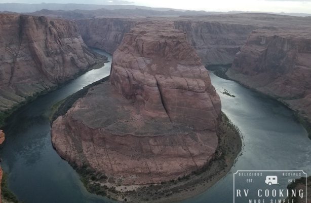
Horseshoe Bend, Glen Canyon National Recreational Area

Horseshoe Bend is a horseshoe-shaped incised meander of the Colorado River located near the town of Page, Arizona, in the United States.
Horseshoe Bend is located 5 miles downstream from the Glen Canyon Dam and Lake Powell within Glen Canyon National Recreation Area. It is accessible via hiking a 1.5-mile round trip from U.S. Route 89. Horseshoe Bend can be viewed from the steep cliff overlook that is 4,200 feet above sea level, and the Colorado River is at 3,200 feet above sea level, making it a 1,000-foot drop. This place has become highly memorable and many people seek it out when they are in the Grand Canyon area.
We arrived at the parking lot just at dusk hoping to capture the sun setting with Horseshoe Bend in the foreground. Unfortunately, for my daughter and I there was some significant could cover and there was no sunset to capture. However, the view of the Colorado River as it twists through sandstone cliffs in a 270 degree angle, just spectacular.
***************************************************************************************************************
This post contains affiliate links, so I make a small commission if you purchase through my links – that support helps to keep this blog running.
Copyright Foodie Made Simple, LLC. All text, recipes and photographs are copyrighted and may not be published elsewhere without express permission. Pinterest, Twitter, Instagram, Tumbler, Google+ and Facebook users, you are welcome to “pin” photos! re-tweet and “share” links all you like, just don’t copy the recipes themselves. Fellow bloggers are welcome to repost my recipes, just write the recipe in your own words, use your own photograph, then link back to the original recipe on rvcookingmadesimple.com


Comments are closed.