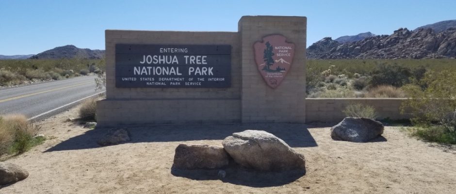
Joshua Tree National Park

February 23, 2019
The Oasis Visitor Center

The Oasis Visitor Center serves the Oasis of Mara area of Joshua Tree National Park and is located on National Park Drive in Twentynine Palms, Calif. This is actually considered the main visitor center for the park, and is open 8:30 a.m. to 5 p.m. daily.
Oasis of Mara
Located at the Oasis Visitor Center in Twentynine Palms, this easy nature trail loops through a natural oasis for which the town of Twentynine Palms is named. The area’s original residents, the Serrano people, called the area Mara, meaning “the place of little springs and much grass.” Legend has it that they came to the area because a medicine man told them that if they settled here, they would have many baby boys. In their first year here, the Serrano planted 29 palm trees at the oasis.
By 1870, when miners began to drift into the area, the character of the oasis changed as mines began to siphon away water and trees were cut down. Soon thereafter, cattlemen moved in and by 1913, the Serrano and Chemehuevi people who had joined them, were all gone.
In 1950, the Twentynine Palms Corporation donated the Oasis of Mara to the National Park Service to use as its headquarters and primary visitor center.
North Entrance
There are three park entrance stations, the west entrance, north entrance and south entrance. The north entrance is in Twentynine Palms, three miles south of the junction of Highway 62 and Utah Trail. Upon entering the park, Utah Trail changes to Park Boulevard.
Arch Rock Nature Trail
The easy Arch Rock Nature Trail weaves through large rock piles to the arch for which it is named.

The trail leaves from the White Tank Campground and passes lots of other interesting boulder formations on the way to the arch.

The highlight of the trail is Arch Rock, which is tucked between large boulders a few steps off the main path.
Arch Rock

While perhaps not as big a draw as the arches in Arches National Park, Arch Rock is nonetheless a pretty spot. The formation is about 30 feet across, and some say it resembles a brontosaurus with its thin neck.

The easy Arch Rock Nature Trail weaves through large rock piles to the arch for which it is named.
Silver Bell Mine

About three-quarters of a mile south of Pinto Basin Road is the Silver Bell Mine, which operated between 1934 and 1962.

Two ore bins, a dirt-covered shelter and an abandoned mine road remain.


The ore bins fed rock to a stamp battery, which crushed it into a sandy, watery pulp from whence precious metals were extracted. Although it’s called the Silver Bell Mine, it produced no silver, only gold, lead and copper.

It’s an easy hike off the road to get to the mine and the view from the top of the mine is amazing.

Cholla Cactus Garden

The Cholla Cactus Garden exists in the unique ecosystem created by the merger of the upper Mojave Desert and the lower Colorado Desert, and a .25-mile loop trail off Pinto Basin Road provides great access to this large concentration of the plant.


Although this cactus has been called the cutest on Earth — even nicknamed the “teddy bear” cactus — beware, as spines will latch onto your skin or clothing with the slightest touch.

When leaving the park out the south entrance we were greeted with fields of blooming wild flowers, a nice treat.


Just south of the parks south entrance off Cottonwood Springs Road there are great boondocking spots, both on the west and east side. This is the spot we selected on the east side of Cottonwood Springs Road and it was surrounded by wildflowers. GPS: 33.675016, -115.781583


*************************************************************************************
This post contains affiliate links, so I make a small commission if you purchase through my links – that support helps to keep this blog running.
Copyright Foodie Made Simple, LLC. All text, recipes and photographs are copyrighted and may not be published elsewhere without express permission. Pinterest, Twitter, Instagram, Tumbler, Google+ and Facebook users, you are welcome to “pin” photos! re-tweet and “share” links all you like, just don’t copy the recipes themselves. Fellow bloggers are welcome to repost my recipes, just write the recipe in your own words, use your own photograph, then link back to the original recipe on rvcookingmadesimple.com


Comments are closed.